Showing posts with label Sierra scenery. Show all posts

Thursday, September 6, 2012

"Up at Rock Creek" 6x8 oil


From Joe Mancuso's blog...


Available Through Coons Gallery In Bishop California. 300. framed http://coonsgallery.com/Coons_Gallery/Welcome.html

I painted this piece while I was up at Rock Creek a couple of weeks ago. This is the scene right before arriving at Rock Creek Lake. Before arriving, I had already planned on painting from this location so I was already thinking about values, colors and shapes etc. You could say I was already painting it before I arrived. I had thought about the granite on the mountains and the blue sky and how they related to each other. I was also thinking about the apsens and if the greens used would be warm or cool or both? When I first arrived and setup my easel I noticed the shadows across the road and how they would be the first shapes to change, so I quicky made shape and color notes for those as well as the shadows on Mount Abbott. From that point on I roughed in the biggest shapes and then worked more on the details later. When I began painting, the sky was clear and when I finished it looked like it might rain. Experiences like this keep me excited and motivated to paint on location often.

Wednesday, May 2, 2012

Rock Creek Pack Station in the WSJ...

Into the Wild West 

A suburban family's thrilling, chilling, life-changing trip through the beyonds of the Sierra Nevada 

By LISA BANNON

MOUNTAIN CLAN | Crossing a stream on horseback, in the eastern slopes of the Sierra Nevada. George Steinmetz
It wasn't until we reached the summit of Mono Pass, a spectacular trail carved 12,150 feet up in California's Sierra Nevada, that my maternal alarm bells went off.

Ahead of me, my husband and three children were about to descend a series of steep, narrow switchback trails littered with loose granite rocks—on horseback.

Suddenly, hazards seemed to be everywhere. The altitude was winding the horses. Bears lurked in the vast forest below. Mountain lions obviously lay in wait. The words of Craig London, the owner of Rock Creek Pack Station who'd sent us on our six-day trip that morning, echoed in my head. "You're completely dependent on your stock," he said, looking us in the eye. "If a horse trips and falls, you die."

Terror was not what I had envisioned when my husband, an intrepid traveler, proposed taking our suburban New Jersey children on an outdoor adventure. Ages 12, 9 and 9, the kids were growing up much more "indoors-y" than out—to them, "the wilderness" might as well have been a sequel to "Angry Birds." George wanted to give them a memorable experience and teach them some basic survival skills before they became completely alienated from the natural world. He assured me that they would be more than fine without the antibacterial wipes, helmets and location-tracking iPhone apps that we had come to rely on at home. The physical discomforts, he argued, would be worth it.

I agreed in principle. But in reality, I had no idea how painful it would be for a self-confessed helicopter mom to relinquish control in the woods. 

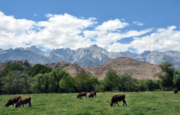
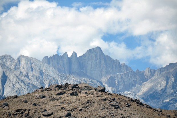
For an authentic experience—far from hotels or Internet access—George chose a remote section of California's Sierra Nevada, a snow-capped range that includes Mount Whitney, Yosemite National Park and some of the last uninhabited wilderness areas in the contiguous U.S. Its backcountry trails are accessible only on foot, no motors allowed.

Mr. London recommended we explore the John Muir Wilderness, 589 miles of trails through sapphire lakes, granite peaks and pine forests, named after the Western naturalist and set aside as part of the 1964 Wilderness Act. Mr. London furnished us with horses, a guide, a cook, camping equipment and food. Five mules hauled our gear and six bottles of good California wine (my secret to survival), over the pass to set up our camp—14 miles from the nearest road—in advance.

I asked what would happen in an emergency. Mr. London, who trains special forces in backcountry navigation, shrugged: "Oh, you'll suffer for a day while they ride out for help. It's the wilderness—there are risks!"

But even he wasn't totally cavalier. Unless our kids wore "protective head gear" on the horses, we'd have to sign a release, he said. This was a no-brainer for me, but George strongly disagreed. "Cowboys don't wear 'protective head gear,'" he said.

I reluctantly stood down, mindful of my promise not to hover. The horses never faltered. And after seven hours, our helmetless children emerged unscathed from their descent over the pass, giddy with the adventure of it all. I recovered from my heart palpitations as we arrived at camp.

Catch trout and have a picnic.  George Steinmetz
Tucked beneath the imposing 12,000-foot Mono Rock, the campsite looked out on the kind of landscape our family had only experienced while watching "The Sound of Music"—a lush valley with a babbling brook flowing through it. Nick and John were amazed that they would be brushing their teeth in a creek. I, meanwhile, was fixating on Giardia lamblia. My guidebook warned that the parasite could be found in some Sierra lakes and streams, and should be avoided by boiling and filtering all drinking water.

This (I thought) helpful advice was dismissed by Ed, the cook; Paul, the guide; and my husband. "Been coming here for years. Never got that," said Paul, a plain-spoken Texan who'd worked the rodeo circuit. 

Besides, he said, there were other concerns. Ed had spotted bear scat around the campsite, meaning a visit was possible. While this thrilled 9-year-old Nick, I could only recall the group of teens who'd recently been mauled by a grizzly in Alaska.

Paul explained that although they adorn California's flag, grizzlies are extinct in the state. Local black bears generally don't attack humans unless you get between a mother and cub or food is involved. Our food, he pointed out, would be sealed in metal canisters and kept away from our tents.

By day three, it was very clear that the instincts that granted me undisputed authority in suburbia were useless in the mountains. My husband's skill set was now ascendant: He could read a topographic map, gut a fish and follow tracks to find his way back to camp. He took us on trips to sparkling high-altitude lakes and meadows bursting with wildflowers where we would hike, catch trout and picnic.

One afternoon, while George and the boys were out hiking, Ed and Paul needed to go wrangle the horses. The sun was setting and I couldn't stop thinking about the bear.

"Do you want my gun?" Paul asked. Nell, age 12, whose entire experience with firearms involved a squirt gun in our backyard pool, asked meekly, "What's it for?"

"Horse shootin'. Bear shootin'. People shootin', if necessary," said Paul, spitting out a wad of chewing tobacco.

By day five, I could see how self-reliant our kids had become. Nick and John could catch and clean a trout, feed a horse and read a topo map. Nell could identify 24 different wildflowers and tell stories around the campfire.

Yet I was the most unexpected beneficiary of the trip. I didn't learn how to shoot a gun. But I could now tend a fire, identify wild chives and enjoy total silence. As we made our way back up to Mono Pass, we met another group heading down, forcing us to turn around. I maneuvered my horse into a 180-degree turn on one of the steepest sections of the trail. I felt no fear; I'd finally learned to let go.

The Lowdown: Sierra Nevada 

Planning It: Rock Creek Pack Station plans horse and mule trips throughout the eastern Sierra Nevada. Our six-day trip for five cost $6,235. rockcreekpackstation.com

Getting There: Mammoth Yosemite Airport is a 20-minute taxi ride from Tom's Place, the closest town to Rock Creek Pack Station. You can also fly to Reno and drive about four hours to Tom's Place.

What to Pack: Rock Creek has a 30-pound-per-person limit. But bring: air mattress, sleeping bags, rain gear, head lamps, sun and winter hats, bug repellent, sunscreen and cash for tips.

Write to Lisa Bannon at lisa.bannon@wsj.com

 A version of this article appeared April 7, 2012, on page D11 in some U.S. editions of The Wall Street Journal, with the headline: Into the Wild West. 

The online version:  http://online.wsj.com/article/SB10001424052702303816504577307970491146042.html

Wednesday, November 2, 2011

Eastern Sierra Art at Coons Gallery

Just in case anyone might be in the area and interested in some great Eastern Sierra art...


Note that you must RSVP to attend the reception. Here's the Web site with info and images of the paintings they have for sale:
http://www.coonsgallery.com/


Wednesday, October 5, 2011

Fall Colors


On my way home from Mammoth last weekend, I made a brief detour up Rock Creek to see the fall colors. The aspens near Upper Pine Grove and Lower Corral ranged from yellow to orange, and I could see a small spot up the side of Wheeler Ridge that was already red.

Near Upper Pine Grove

Wheeler Ridge

Near the cabin at Lower Corral


The rabbitbrush blanketing the Owens Valley was too gorgeous to simply drive past, so I also pulled over in Olancha and had a brief conversation with the cows about what a perfect day it was.

Olancha


Tuesday, September 20, 2011

One of America's most beautiful highways


Cattle in a field in Lone Pine graze below the magnificent range of the High Sierras in California. In middle right of range is Mount Whitney, the Old One, with its two twin spires on the left of the peak. Betsey Bruner/Arizona Daily Sun


BETSEY BRUNER Arts & Culture Editor
Arizona Daily Sun azdailysun.com
Posted: Sunday, September 18, 2011 5:00 am

When my Phoenix cousin, Brad, asked me to photograph his wedding this summer in Lake Tahoe, Calif., I jumped at the chance for a family reunion, and a road trip.

Planning my route, I decided to get to there via U.S. Route 395 in California, a highway I have long considered one of the most stunning in our country.

A JOURNEY FOR DAD

I also had sentimental reasons for picking that route: My dad, William, who died last July at age 97, had spent many summers in his late teens and later in life hiking and camping in the Sierra Nevada mountain range, which many nickname the High Sierras or the Sierras.

He had also climbed Mount Whitney, which, at an elevation of 14, 505 feet, is the highest mountain in the contiguous United States. The Paiute Indian Tribe had called it the Old Man or the Old One, a fitting name for a stately and dramatic peak.

The steep Sierra Escarpment on the east side of the range parallels the highway for miles and is a huge fault-block created in the Cretaceous Period (145.5-65.5 million years ago) as a molten rock mass rearing up sharply from the west to the east.

The result is a drive with amazing views for hours of lovely, jagged peaks, so it is not surprising this section of the highway is called the Eastern Sierra Scenic Byway. The byway identifies 23 scenic turnouts and interpretive displays from Topaz Lake in north Mono County to Little Lake in southern Inyo County.

The highway also serves as a connection to the Los Angeles area for the communities of the Owens Valley, Mammoth Lakes and Mono Lake and is used as an access for both the highest point in the U.S., Mount Whitney, and the lowest point in North America, Death Valley.

RIDING THE RAILS

Probably the best sightings by car of the granite face of Mount Whitney are from the little town of Lone Pine, whose Whitney Portal (8,360 feet) at the west of the town is the preferred trail and gateway to an ascent of Whitney.

This was the way my dad always went, with his pal, Warren, as they escaped a Los Angeles suffering from the effects of the Great Depression.

They "rode the rails" from L.A., hopping into a passing train without paying, almost like the so-called hobos or homeless vagabonds.

They would probably have to hitch a ride on car or truck from the east-west train line in the Mojave to get to the road north to the Sierra.

Carrying only blanket bedrolls, thin jackets and canvas backpacks, they supplied themselves with slab bacon, canned goods like milk and even carrots and eggs.

They picked up mules at the old mule station at Whitney Portal, and lived for a few months on trout they caught in the many lakes up high.


Mount Whitney, with an elevation of 14,505 feet, is the highest summit in the contiguous United States. As seen from the east side, the two distinctive needles make it easier to spot as it looms just over two miles above the town of Lone Pine in the Owens Valley below. The ancient and worn Alabama Hills are in the foreground. Betsey Bruner/Arizona Daily Sun

MUCH LOCAL HISTORY

Mount Whitney is still considered a challenging but manageable climb for amateurs (with training) and professionals alike, and the little towns below -- Lone Pine, Independence, Big Pine and Bishop, the largest city in the Owens Valley -- offer good eats and cozy places to stay, some with wonderful views of the magnificent mountain range. The range is also part of the larger John Muir Trail, another very popular backpacking route.

Also visible surrounding Lone Pine are the Alabama Hills, the ancient weathered hills of metamorphosed volcanic rock that are about 200 million years old, as compared to the 90-million-year-old granite of the Sierra Nevada range rising sharply behind.

The corridor going through these little towns has been used since the California gold rush. Before our highways were numbered, it was known by several names including El Camino Sierra.

After leaving Kramer Junction on SR 58 in the Mojave Desert and climbing up to higher elevations, travelers can stop at Randsburg, dubbed a living ghost town, for evidence these gold rush days.


The living ghost town of Randsburg (population 69) is in Kern County, Calif., just off U.S. Route 395 as it climbs out of the flatlands near Kramer Junction heading north to the Sierra Nevada or High Sierra mountain range. Gold was discovered at Rand Mine near the site in 1895. It's a fun spot to stop and stretch and even has some places to eat and sleep. Betsey Bruner/Arizona Daily Sun

MANY GREAT STOPS

Randsburg is just one of many very fun sojourns possible as one drives along Highway 395. Other stops include a high concentration of natural hot springs along the way, the Manzanar National Historic Site, a internment camp where Japanese Americans were imprisoned during World War II (near Independence), and, one of the best destinations in the vicinity, Mono Lake.

The lake is located northwest of Bishop as Highway 395 climbs up more than 3,000 feet in elevation, past Crowley Lake, Mammoth Lakes, June and Grant lakes and the community of Lee Vining.

Dating back at least 760,000 years ago, it is a terminal lake in a basin that has no outlet, so that dissolved salts make the lake very alkaline and saline. In fact, Mono Lake has nearly three times the concentration of salt as the ocean.

There is a state-of-the-art visitor center there with many displays to illuminate the story of the lake, including information about the unique and lovely tufa or limestone formations dotting the lake.

GREAT WATER WARS

The ecology of Mono Lake was threatened when Los Angeles extended the Los Angeles Aqueduct system farther upriver into the Mono Basin.

The original system was completed in 1913 when water was diverted from the Owens River, ultimately providing half of the water for Los Angeles and robbing farmers and ranchers of land and water.

This act incited the California Water Wars, a fierce and long-running episode in history, which also inspired the 1974 film "Chinatown."

Highway 395 briefly crosses over into Nevada, where one can cross back over to California on one of the connecting highways at Gardnerville or Minden, and on to South Lake Tahoe, my ultimate destination.

Betsey Bruner can be reached at bbruner@azdailysun.com or 556-2255.

Friday, June 10, 2011

Side Trip to Mammoth Lakes

I apologize for not posting anything here for such a long time; I've been too busy with other projects.

Since I enjoyed this brief story posted on Dave McCoy's blog about the owners of another Eastern Sierra lodge, I thought I'd share it here. Many of you who have visited the Mammoth Lakes area in addition to Rock Creek might have crossed paths with Bob Schotz or visited his Woods Lodge at Lake George. As you'll see in the blog post, he also built several prominent buildings around Mammoth.

Anyway, click here to see their story and photos.

You might also want to poke around in some of Dave McCoy's other posts; he's been sharing a lot of historic photos of Mammoth Mountain and the area in general, in addition to his own recent photography.

Enjoy!


Monday, September 27, 2010

A Different View of Rock Creek

I ran across a trip report by someone who rode their mountain bike up the road and then down the Sand Canyon trail along Wheeler Ridge. Thought you might enjoy the photos too (click on "trip report").  This is a nice one of the store...

Saturday, March 13, 2010

Historic Photos Restored!

Before the exciting visual part, a bit of history. When we sold the Lodge, my dad allowed us to take only a few things; we had sold the place "as is," which included furniture, linens, etc. This was difficult for me, because I knew that many of the furnishings had come from family members' homes over the years. How to leave behind all that personal history (even if my dad, and probably others, considered it junk)?

I carefully selected and negotiated so that I could have the most significant things to forever remind me of my home. Remember the old hand-tinted photos that hung in the Lobby? They were at the top of my list. The one most people probably recall was hanging over the fireplace, with the antlers. It was of Serene Lake. In fact, here it is with us Robys (early 1980s). The other two were of Box Lake and Mono Pass.


For all these years they were stored at my parents' house, but a few months ago they started nagging at me and I had my mom unearth them. Boy, were they in worse shape than we remembered! Over forty years of fireplace smoke and neglect had really taken a toll. Chris and I debated what to do about it and ultimately decided that since they probably couldn't get any worse, we would ask the guy who cleans paintings for us see what he could do with them. Well... we could not believe our eyes. Here are the results! (Click on the images to view them full-size.)

Serene Lake, "before"

Serene Lake, "after"

Box Lake, "before"

Box Lake, "after"

Mono Pass, "after"
(we didn't take a "before" of this one because it was not as damaged)

All three of these photos were taken by the renowned Burton Frasher, which helped me identify what year this one of Mono Pass was taken. We collect Frasher postcards, so I knew the Pomona Public Library has a collection online. Sure enough, look what I found there...

"On Mono Pass Overlooking Rock Creek Basin "
Courtesy, Frasher Foto Postcard Collection, Pomona Public Library

That's Burton Frasher with his camera. By closely comparing the patches of snow, we quickly concluded that our photo was taken during this very photography session, in 1927! I haven't run across the other two yet, so their origin remains a mystery. I guess we can assume they were taken during a similar time period. My dad is pretty sure all of them were already at the Lodge when my grandparents bought it in 1947.

Isn't this fun?!

If you're interested in photography, I highly recommend visiting the online Frasher Foto Postcard Collection. There are over 5,000 images, including many fantastic Sierra scenes. You can narrow the results by choosing decades or using search terms (like Rock Creek). This page provides a biography and description of his amazing career.

Needless to say, I am thrilled to have this part of my history back in my life and I hope you have enjoyed this "before" and "after" tale.

Tuesday, March 9, 2010

1900s Photos on eBay


Wow!  Someone is currently selling over 30 photos of "cowboys" or packers in the backcountry, like the one above, and other scenes around the Bishop/Mammoth area taken in the very early 1900s.  The information is not any more specific than that, but Devil's Postpile is certainly recognizable, as you can see below.  Some of you may be able to identify other locations.  Just thought I'd share in case anyone wants to take a peek before they sell (too pricy for me).  The auctions end in four days, so be quick!  Enjoy...

http://shop.ebay.com/amdatial/m.html?_nkw=1900%27s+sierra&_sacat=0&_trksid=p3911.m270.l1313&_sop=12&_odkw=1900%27s+sierra&_osacat=0

Wednesday, January 27, 2010

Sierra Splendor

I realized I haven't posted anything in a while, so I thought I'd share a couple photos taken on December 28. I shot these from the car as we were heading south in the early morning after a trip to Mammoth. This kind of scenery is what makes it so difficult to leave!


Mount Tom


Sierra crest, west of Bishop

Thursday, October 8, 2009

Hot Off the Easel at the Lodge

Joe Mancuso has been up at Rock Creek this week, painting en plein air in spite of the cold weather.  I thought I'd share the paintings he posted on his blog, Painting Every Day.


A Chance of Snow 8x6 Oil

October 4:  "While this image is being posted, it is snowing outside my cabin. This was painted yesterday in the high sierras of California. There have been very few times that it has been as cold while I've painted on location. The wind was blowing and the weather forecast was calling for a chance of snow. I loved it. This morning I awoke to snow on the ground. A treat for this southern Californian. This piece is available at Rock Creek Lodge."


October Snow 6x8 Oil

October 7:  "Last Monday morning, I awoke to a temperature of 8 degrees. It had warmed up to a balmy 17 by the time I began painting this piece. Although there have been times when it can be too much to deal with, I enjoy painting in extreme weather conditions because it is part of the excitement of working on location. I love to see if I can capture the moment. This piece is available at Rock Creek Lodge."

Sunday, August 23, 2009

Robys in Mammoth/Rock Creek

As mentioned in my last post, my parents and I went to Mammoth for a brief visit at the beginning of August. Our first morning we canoed around Lake Mary in the old blue and white canoe from the lodge. Yes, it still gets occasional use, but it's getting heavier and heavier the older we get, so I'm not sure we'll be using it much longer. This is Rusty, keeping a close watch on the paddles; he was determined to catch one of those darn things.


A few years ago my parents switched to kayaking. So much lighter and easier to transport! I got to test-drive my dad's at Twin Lakes while he stayed on shore. As you can see, Mom is an old pro in hers.


Saturday night the Von Rohr family (3 generations) joined us for dinner at Slocums. Naturally, there was nonstop reminiscing about "the good old days." And it sounds as if Eric and Mark are doing a great job introducing Eric's kids to all the things we used to do together, even rebuilding our forts.

We finally got our dose of Rock Creek on Sunday. With two aging and unpredictable dogs in tow, we decided that a quick jaunt to Serene would be enough (I have carried 30-lb. Rusty down the McGee Creek trail—not fun). Serene is still one of the most vivid places in my memories, but none of us had been there in ages. As expected, nothing has changed; it still lives up to its name...


We circled the lake and then simply enjoyed the tranquility for a while.


Afterward we did a brief cruise of Mosquito Flats and around the lake, then headed to the Lake Store for pie. YUM. We also drove through the lodge grounds and stopped briefly to say hello again to the Von Rohrs. We checked out the changes in Cabin 11. Different, but nice. I was pleased to see a painting by Joe Mancuso on the wall.

Every time I go back it does get easier, but it still wrenches emotions. Every square inch of the grounds and beyond holds so many memories and they all suddenly come rushing back. It's amazing how minute details from 30+ years ago can remain burned so clearly in one's mind.

As we were driving out, I remarked how much the meadow has returned to forest. Remember when it was just open grass, filled with shooting stars?

Friday, June 19, 2009

"The Bridge View"


Summer is almost here, so folks are starting to make their pilgrimages to Rock Creek and other parts of the Eastern Sierra. Joe Mancuso recently posted this painting of the creek from the upper bridge at the lodge on his Painting Every Day blog. He so skillfully captured the scene, I thought others would enjoy it too.

Sunday, January 27, 2008

Historic Frashers Postcards, etc.

We collect "Frashers Foto Cards" - postcards of photos taken by the famous photographer Burton Frasher. I have scanned some of the ones of Rock Creek and posted a slideshow. A few of them were actually mailed by visitors to Rock Creek (in the '40s and '50s), so it's interesting to read their messages. I also included an old brochure for the lodge I recently purchased. It's from the days prior to Roby ownership and lists the owners as Mr. & Mrs. F. P. Baugh. Note the use of Frasher's images throughout.