


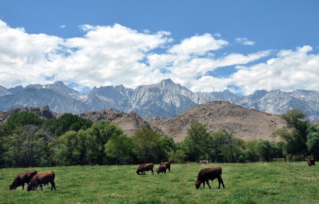
Cattle in a field in Lone Pine graze below the magnificent range of the High Sierras in California. In middle right of range is Mount Whitney, the Old One, with its two twin spires on the left of the peak. Betsey Bruner/Arizona Daily Sun
BETSEY BRUNER Arts & Culture Editor
Arizona Daily Sun | azdailysun.com
Posted: Sunday, September 18, 2011 5:00 am
When my Phoenix cousin, Brad, asked me to photograph his wedding this summer in Lake Tahoe, Calif., I jumped at the chance for a family reunion, and a road trip.
Planning my route, I decided to get to there via U.S. Route 395 in California, a highway I have long considered one of the most stunning in our country.
A JOURNEY FOR DAD
I also had sentimental reasons for picking that route: My dad, William, who died last July at age 97, had spent many summers in his late teens and later in life hiking and camping in the Sierra Nevada mountain range, which many nickname the High Sierras or the Sierras.
He had also climbed Mount Whitney, which, at an elevation of 14, 505 feet, is the highest mountain in the contiguous United States. The Paiute Indian Tribe had called it the Old Man or the Old One, a fitting name for a stately and dramatic peak.
The steep Sierra Escarpment on the east side of the range parallels the highway for miles and is a huge fault-block created in the Cretaceous Period (145.5-65.5 million years ago) as a molten rock mass rearing up sharply from the west to the east.
The result is a drive with amazing views for hours of lovely, jagged peaks, so it is not surprising this section of the highway is called the Eastern Sierra Scenic Byway. The byway identifies 23 scenic turnouts and interpretive displays from Topaz Lake in north Mono County to Little Lake in southern Inyo County.
The highway also serves as a connection to the Los Angeles area for the communities of the Owens Valley, Mammoth Lakes and Mono Lake and is used as an access for both the highest point in the U.S., Mount Whitney, and the lowest point in North America, Death Valley.
RIDING THE RAILS
Probably the best sightings by car of the granite face of Mount Whitney are from the little town of Lone Pine, whose Whitney Portal (8,360 feet) at the west of the town is the preferred trail and gateway to an ascent of Whitney.
This was the way my dad always went, with his pal, Warren, as they escaped a Los Angeles suffering from the effects of the Great Depression.
They "rode the rails" from L.A., hopping into a passing train without paying, almost like the so-called hobos or homeless vagabonds.
They would probably have to hitch a ride on car or truck from the east-west train line in the Mojave to get to the road north to the Sierra.
Carrying only blanket bedrolls, thin jackets and canvas backpacks, they supplied themselves with slab bacon, canned goods like milk and even carrots and eggs.
They picked up mules at the old mule station at Whitney Portal, and lived for a few months on trout they caught in the many lakes up high.
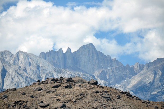
Mount Whitney, with an elevation of 14,505 feet, is the highest summit in the contiguous United States. As seen from the east side, the two distinctive needles make it easier to spot as it looms just over two miles above the town of Lone Pine in the Owens Valley below. The ancient and worn Alabama Hills are in the foreground. Betsey Bruner/Arizona Daily Sun
MUCH LOCAL HISTORY
Mount Whitney is still considered a challenging but manageable climb for amateurs (with training) and professionals alike, and the little towns below -- Lone Pine, Independence, Big Pine and Bishop, the largest city in the Owens Valley -- offer good eats and cozy places to stay, some with wonderful views of the magnificent mountain range. The range is also part of the larger John Muir Trail, another very popular backpacking route.
Also visible surrounding Lone Pine are the Alabama Hills, the ancient weathered hills of metamorphosed volcanic rock that are about 200 million years old, as compared to the 90-million-year-old granite of the Sierra Nevada range rising sharply behind.
The corridor going through these little towns has been used since the California gold rush. Before our highways were numbered, it was known by several names including El Camino Sierra.
After leaving Kramer Junction on SR 58 in the Mojave Desert and climbing up to higher elevations, travelers can stop at Randsburg, dubbed a living ghost town, for evidence these gold rush days.
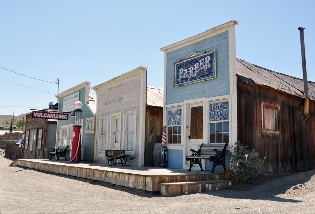
The living ghost town of Randsburg (population 69) is in Kern County, Calif., just off U.S. Route 395 as it climbs out of the flatlands near Kramer Junction heading north to the Sierra Nevada or High Sierra mountain range. Gold was discovered at Rand Mine near the site in 1895. It's a fun spot to stop and stretch and even has some places to eat and sleep. Betsey Bruner/Arizona Daily Sun
MANY GREAT STOPS
Randsburg is just one of many very fun sojourns possible as one drives along Highway 395. Other stops include a high concentration of natural hot springs along the way, the Manzanar National Historic Site, a internment camp where Japanese Americans were imprisoned during World War II (near Independence), and, one of the best destinations in the vicinity, Mono Lake.
The lake is located northwest of Bishop as Highway 395 climbs up more than 3,000 feet in elevation, past Crowley Lake, Mammoth Lakes, June and Grant lakes and the community of Lee Vining.
Dating back at least 760,000 years ago, it is a terminal lake in a basin that has no outlet, so that dissolved salts make the lake very alkaline and saline. In fact, Mono Lake has nearly three times the concentration of salt as the ocean.
There is a state-of-the-art visitor center there with many displays to illuminate the story of the lake, including information about the unique and lovely tufa or limestone formations dotting the lake.
GREAT WATER WARS
The ecology of Mono Lake was threatened when Los Angeles extended the Los Angeles Aqueduct system farther upriver into the Mono Basin.
The original system was completed in 1913 when water was diverted from the Owens River, ultimately providing half of the water for Los Angeles and robbing farmers and ranchers of land and water.
This act incited the California Water Wars, a fierce and long-running episode in history, which also inspired the 1974 film "Chinatown."
Highway 395 briefly crosses over into Nevada, where one can cross back over to California on one of the connecting highways at Gardnerville or Minden, and on to South Lake Tahoe, my ultimate destination.
Betsey Bruner can be reached at bbruner@azdailysun.com or 556-2255.